Monday, October 25, 2010

Getting Lost in the Mojave Desert

We took off on I-40 again this morning, heading west through the Mojave Desert.

The desert is mostly flat and dry, with craggy mountains growing out of the sand.

A deep low pressure system passed through the region a day or so ago, and the result was high winds with gusts up to 65 mph in some parts of California. We didn't get the really high winds, but they were gusty and strong enough to blow us all over the road - a scary experience on a highway posted at 70 mph. We had to slow down and ride with our hazard lights on as cars flashed past us with a speed differential of 30 to 40 mph.

Our aim was to head north to Shoshone, and we turned north at exit 100. The road led us through the desert to Mitchell Caverns where the road turned to gravel. Chris realised a better route would have been to turn north at exit 78, so we returned to I-40 and turned west. With the strong head winds and the extra miles we travelled, we were in need of fuel before we headed out again across the desert. This is not a place to run out of fuel.

This meant riding 49 miles west to Ludlow. The winds seemed to get stronger the further we went. By the time we arrived there, we were both frazzled from fighting the winds. We stopped for a slow lunch at a fast food joint. You can see how the wind was nearly ripping the top off this palm tree...
The winds had died down a bit by the time we were ready to go. Also, we had to ride 29 miles east back to Kelbaker Road, which meant the winds were at our back and had less effect on us.

Turning north on Kelbacker Road we soon reached Kelso. There wasn't a single wheel barrow in sight, let alone a factory to make them... Taking a left at the fork in the road we wound across the desert towards the town of Baker. This is a wild and lonely place..

We had decided earlier that if the weqather was still bad we woulkd stay here the night. As it turned out we had a good run across the desert and so we decided to push on to Shoshone, our planned destination for the night. Besides, the "Bun Boy Motel" didn't seem like our kind of place. Before tackling the last 56 miles we stopped for coffee and a rest at the Mad Greek Cafe (appropriately decorated with dozens of fibreglass replicas of classical sculptures.)


The road to Shoshone took us through more desert, with a very different flora to the more southerly parts of Mojave.

The road to Shoshone was even lonlier than those we rode earlier in the day.

The desert became more arid and the vegetation more sparse as we rode on.

Shoshone is a very small town (Population: 25). It does have a hot spring in which we could have bathed.


We ate at the Crowbar Cafe, the only restaurant in town.

Getting our kicks...

We left Williams this morning after hearing the "all aboard" call from the nearby railway station form which trains run to the South Rim of Grand Canyon, 57 miles north. That sounds like a neat way to visit the canyon...

Twenty five miles down I-40 we took exit 139 to Seligman, and in doing so began our journey down one of the last remaining stretches of historic Route 66, the "Mother Road" od America.


Seligman is a quirky little town that is cashing in BIG time on Route 66 tourism.

We didn't stop there. but rather just cruised through slowly before pressing on to Peach Springs where we planned to get petrol. That was pretty much a ghost town, with no services. We were able to fill up in Truxton, but apart from the service station, there was nothing much there either.

We took our lunch break at Mr D's Route 66 Diner in Kingman AZ.


From Kingman, Route 66 headed across Sitgreaves Pass. At less than 4000 ft, it is not particularly high, but the road up to the top is a narrow strip of old blacktop that clings to the side of the mountain and winds in and out of every gully on the hillside. There are no guard rails, and some off the drop-offs at the side of the road are high and steep.

Once across the top, the road down the other side is much easier, and not far from the pass we reached the tourist mecca of Oatman.

This was a mining town, but the ore ran out. The miners then released their donkeys, used to pull carts of ore out of the mines, into the wild, and they bred as furry animals with long ears usually do. Now they wander the main street looking for tourists with carrots or other food, all of which are in plentiful supply.

There were a lot of bikes in town, and a greater than usual proportion were BMWs. We quickly got talking to Grant and Gary, two members of EMO, the European Motorcycle Owners club (aka Eat More Often) based in Las Vegas.

They told us of a meeting of BMW owners every Saturday morning at the BMW dealer's, from where they ride to lunch somewhere. Since we are going to be in Las Vegas next Saturday, we are planning to join them.

Every building in Oatman is given over to selling t shirts/handbags/carrots/junk food/beer/all manner of tacky souvenirs. We couldn't resist stopping, wandering around and feeding some of the donkeys.
Route 66 rejoined I-40 in Topock, where they crossed the Colorado River into California. We stopped for the night in Needles, CA. Once again we were lucky and found a motel within walking distance of a supermarket. It was a shame the internet didn't work in our room...

Meteor Crater

After a wonderful night at the La Posada hotel, we rode off west on I-40.

We met a Yamaha rider at the petrol station, going out to enjoy the day on his spotless bike.
About 20 miles down the road we turned off down Meteor Crater Road to visit the world's "first identified and best preserved" meteor crater. They reckon that a 45 m diameter iron meteor landed here about 50,000 years ago. It weighed a lot and was travelling very fast, so it dug a very big hole - 1.2 km across and several hundred metres deep.

Returning back to I-40, we continued into Flagstaff, where we had lunch and rang around to see if we could get a back tyre for our motorbike on a Saturday afternoon. The last one was getting pretty ratty, with pronounced "scoops" on either side of the centre tread. There was a bloke at the restaurant in desperate need of a life. We soon found a place that could do it and headed off after lunch. Finding them was something of a challenge. Their address was "E(ast) Route 66". When Chris typed it into the GPS it found the road, but when Chris "accepted" this, the GPS inextricably changed the address to W(est) Route 66. This was not expected and went unnoticed until we ended up in the middle of nowhere, 7 miles west off Flagstaff.

Eventually we found the place and had a new rear tyre fitted. By then it was getting late, so we decided to continue only to Williams, another 30 miles down I-40, rather than press on to Seligman. It was a good decision. We found a motel across the road from a supermarket that was comfortable, well appointed and very reasonably priced.

Saturday, October 23, 2010

Standin' on the Corner in Winslow Arizona

Our alarm woke us to a cloudy but dry day.

Once packed we rode the short distance to the Yavapai Overlook, Arizona. The clouds were very heavy, but at least the ceiling was above the canyon, and we were able to take in the magnificent view, hazy though it was. In some places the sun broke through the clouds and illuminated parts of the canyon in the distance, so we could see some of the magnificent colours in the rocks.


We rode to another overlook a mile or so further on and took in another perspective.

The weather conditions were not improving, so we decided to head off to Flagstaff rather than spend more time at the canyon.

Flagstaff was about 90 miles away, and we managed to put 70 miles under our wheels before running into rain. The last 20 miles int o Flagstaff were quite unpleasant. The road took us to over 8,000 ft so it was not only wet but extremely cold. Our bike said it was 41 F, but it felt much colder. Chris had 4 layers of clothing under his wet weather gear and was still shivering. It was good to stop at the first diner we saw and warm up.

By the time we were back on the road the rain had stopped. We left our wet weather gear on for warmth as we headed east on I-40 to Winslow, made famous in the Eagle's song "Takin' it Easy"

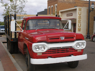
Winslow has been cashing in ever since. There is a bronze statue on the corner of E 2nd St and N Kinsley Ave, and a trompe l'oeil mural of the girl in the flatbed truck. A real flatbed truck is parked in the street.


Our main reason for visiting Winslow was to stay in the famous and historic La Posada Hotel, the last of the great railway hotels, and an icon for Route 66 fans. (E Second St that runs past the hotel was part of Route 66.). This was a birthday present to Chris from a very good friend.


Our room had a luxurious spa bath, great for soaking away the miles. We spent some time exploring the building and grounds before making a booking for dinner in the Turquoise Room, one of the best restaurants in Arizona, according to the reviews.

We had a bath in the spa, dressed for dinner, and went down to the bar for predinner drinks. We both chose elk steaks for dinner, accompanied by a fine bottle of shiraz. In our opinion the cheff is world class. The creme brulee we had for dessert was very nice, nearly as good as Kim or Michel make for us back home. It was a superb place to stay and eat. Very special.